Showing posts with label BPCC. Show all posts

Wednesday, April 3, 2019

April 30th is last chance to provide input to the Sanibel Shared Use Path Master Plan

Since February, the City of Sanibel has been working on the update of its Shared Use Path Master Plan, and the period of public input ends on April 30th.  If you live, work, or play on Sanibel, please take advantage of one or all of the channels and opportunities for participating in the update of the City’s Shared Use Path Master Plan.  www.sanibelbikeped.com Public input is important for developing a visionary plan (with a 10-20 year time horizon) for one of the community’s crown jewels—its shared use path system.  Be sure to check out the cool Interactive Comment Map online, which is easy to use (see step by step instructions below) http://www.sanibelbikeped.com/interactive-comment-map/


Background
The City of Sanibel’s Shared Use Master Plan was adopted in 2009 and has guided the implementation of updates to our shared use path system over the past decade. The City of Sanibel, in collaboration with the Lee County Metropolitan Planning Organization (MPO), is currently updating the Sanibel Shared Use Master Plan. The Master Plan Update is being conducted to recognize the improvements completed over the past decade and will guide the long-term vision for the Shared Use Path system. During this process the City and MPO will solicit and receive public comment through a variety of channels including Open Houses, surveys and emails. A webpage has been created just for the Update of the Sanibel Shared Use Path Master Plan project now underway. www.sanibelbikeped.com

How to Participate:
There are three ways you can still provide your input to Sanibel's Update of its Shared Use Path Master Plan:
1. On Monday, April 22, 2019 the community is invited to drop-in any time between 10 a.m. to 6 p.m. to share citizen input and recommendations to date for the Shared Use Master Plan Update . The Open House is being held at the Sanibel Recreation Center, 3880 Sanibel Captiva Road, Sanibel, FL 33957.
2. You can respond to an online survey with the click of your mouse.
3.  Input comments about specific locations on Sanibel where you have comments, concerns, or suggestions by using the Interactive Comment Map.
4. The project website www.sanibelbikeped.com also has links to the Project Calendar, Resources (which includes previous studies and source documents related to the Master Plan), and a “Contact Us” button to allow you to communicate with the project management team.


INSTRUCTIONS FOR THE INTERACTIVE COMMENT MAP
This is an excellent online tool for using the map of Sanibel to indicate specifically where you have concerns, comments, and ideas.  You can also see everyone else’s comments and can comment on their comments.  It is easy to use, once you have a few instructions:
1. The link to the website is: www.sanibelbikeped.com. This site includes links at the top (orange icons) to the following components:
2. Click on orange icon, "Interactive Comment Map". http://www.sanibelbikeped.com/interactive-comment-map/
3. Then move to the Green heading below and click on the tab "About and Help".
4. A drop down menu will appear. Click on "Instructions" tab.
 
5. Instructions for using the Map:
  • To begin the comment process; please zoom to your location of interest.
  • Once you have identified the location, click on the “Issues and Concerns” tab in the header.
  • Click on the map at the location that you wish to identify as an issue or concern – a comment box will appear for you to describe the specific issue or concern.
  • Once you are done entering your comments, please click on “Submit.”
  • If someone has already identified a similar issue at the same location, you can click on the icon to view the respective comment.
  • If you wish to Agree or Disagree with the comment or want to add an additional comment, please click the Show Comments/Surveys button to provide your input.
  • Click “Add Comment” once you have completed your entry.
Don't forget to participate before April 30th!

Monday, March 18, 2019

On March 25th Plan to attend Estero's final Bike/Ped Workshop


Plan to attend Estero’s final Bike/Ped workshop 
on Monday, March 25, 2019


When:
Monday
March 25, 2019
5 - 7 p.m.


Where:
Estero Community Park
Recreation Center
Want to learn about the preliminary results and findings of Estero’s first Bicycle & Pedestrian Master Plan?

Please plan on attending the final public workshop at 5 – 7 p.m., Monday, March 25, at the Estero Community Park Recreation Center.

The workshop will provide a brief summary of the overall project. But the focus will be on the preliminary results and recommendations of the master plan. 
Topics will include:

  • Public Engagement Results
  • Bicycle & Pedestrian Vision and Goals
  • Draft Recommendation

Residents will have time to provide input and feedback about each topic as well as any interests related to bicycle and pedestrian facilities within Estero. 

Hope to see you there.

Tuesday, January 29, 2019

Action Alert: Attend Feb. 7th public hearing for Able Canal Pathway Project in Lehigh Acres


If you live, work, or play in Lehigh and support the proposed 5.5 mile pathway that will connect Lehigh Acres Trailhead Park, to the Lehigh Acres Community Park and the Harnes Marsh, allowing residents and visitors to bike or walk between these popular destinations, now is the time to make your voices heard. This FDOT-funded project has been in the study/planning phases since 2013, and is now at the stage of a public hearing prior to approval of the location of the pathway along the canal and its conceptual design.  This is your chance to review the proposal and share your views with FDOT, Lee County, and MPO staff.

  It's important that pathway supporters attend this public hearing to show their support for moving forward to implementation of this important project.

Read  BWL's March 2017 blog post for background on the project and BWL's April 2018 blog for background on the open house to review alternatives under consideration.

 FDOT Press Release:

The Florida Department of Transportation (FDOT), District One, invites you to attend a public hearing for the Able Canal Pathway from Harns Marsh to Joel Boulevard (CR 884) project in Lee County, Florida. 

Public hearing:
  • Date: Thursday, February 7, 2019
  • Time5 p.m. Open house
  •  6 p.m. Formal presentation and public comment period
  • LocationVeterans Park Recreation Center
  •  55 Homestead Road South
  •  Lehigh Acres, FL 33936
Location of Able Canal Corridor
The proposed improvements consist of constructing a new shared-use pathway along the north side of Able Canal where there is currently no continuous path. This public hearing is being conducted to give interested persons an opportunity to express their views concerning the location, conceptual design, and social, economic, and environmental effects of the proposed improvements.

Draft project documents will be available for public review from Thursday, January 17, 2019 to Monday, February 18, 2019 at the following locations: East County Regional Library, 881 Gunnery Road North, Lehigh Acres, FL 33971 and FDOT District One, Southwest Area Office, 10041 Daniels Parkway, Ft. Myers, FL 33913.

The environmental review, consultation, and other actions required by applicable federal environmental laws for this project are being, or have been, carried out by FDOT pursuant to 23 U.S.C. §327 and a Memorandum of Understanding dated December 14, 2016 and executed by the Federal Highway Administration and FDOT.

FDOT solicits public participation without regard to race, color, national origin, age, sex, religion, disability, or family status. People who require special accommodations under the Americans with Disabilities Act or who require translation services (free of charge) should contact Cynthia Sykes, District One Title VI Coordinator, at (863) 519-2287, or e-mail at Cynthia.Sykes@dot.state.fl.us at least seven days prior to the public meeting.

If you have questions about the project or scheduled public hearing, please contact Steven Andrews, Project Manager at (863) 519-2270 or by e-mail to steven.andrews@dot.state.fl.us at least seven days prior to the hearing. You can also visit the project website at www.swflroads.com/ablecanalpathway.

Wednesday, June 6, 2018

Invite to June 19th Open House on Proposed Bayshore Rd. Pathway

Do you live, work, or play in Bayshore Road area (State Road 78)?  Here's your chance to find out the options FDOT is considering for a proposed pathway on Bayshore Rd. Stop by the Open House on Tuesday, June 19th (any time from 5-7 p.m.) to learn more and provide your input.


June 5, 2018                                                                           
                                                                                                   Zachary.Burch@dot.state.fl.us

 
FDOT Public Information Meeting for Bayshore Road (State Road 78) Pathway

from Park 78 Drive to State Road 31 in Lee County

Fort Myers, FL – The Florida Department of Transportation (FDOT), District One, is holding a public information meeting about the Project Development and Environment (PD&E) study for the proposed pathway improvements along Bayshore Road from Park 78 Drive to State Road 31 in Lee County, Florida.

The meeting will be held from 5 p.m. to 7 p.m. on Tuesday, June 19, 2018, at the Lee Civic Center, Whaley Hall Building at 11831 Bayshore Road, Fort Myers, FL.

The meeting will be an open house format with a video presentation playing continuously throughout the meeting. There will be no formal presentation. Department staff will be available to discuss the project, to receive public input, and to answer any questions.

This meeting is being held to allow interested persons an opportunity to be informed and provide comments concerning the location; conceptual design alternatives; and social, economic, and environmental effects of the proposed project for the Bayshore Road (State Road 78) Pathway. The proposed project will provide a safe, viable non-motorized travel option for commuters and recreational users along the Bayshore Road corridor and the Fort Myers community, improving multimodal accessibility to area destinations while minimizing potential impacts to the natural and human environments. Alternatives being evaluated for this project include either a sidewalk or a shared use path on the north or the south side of Bayshore Road. The No-Build Alternative, which assumes that no pathway will be provided along Bayshore Road through the year 2040, is also an option and will remain a viable alternative throughout the PD&E study.

You can also stay current with the project and share comments with the study team by visiting the Bayshore Pathway web page at www.swflroads.com/bayshorepathway.


Thursday, April 26, 2018

Attend May 17th Open House re: Abel Canal Pathway Project

If you live, work, or play in Lehigh and support the proposed 5.5 mile pathway that will connect Lehigh Acres Trailhead Park, to the Lehigh Acres Community Park and the Harnes Marsh, allowing residents and visitors to bike or walk between these popular destinations, now is the time to make your voices heard. This proposed FDOT-funded project has been in the study/planning phases since 2013, and is now at the stage that alternative locations and conceptual designs are available for public input.  It's important that pathway supporters attend this open house to show their support for moving forward to implementation of this important project.Read  BWL's March 2017 blog post for background.

FDOT Press Release 4/25/18________________________________________________________________
The Florida Department of Transportation (FDOT), District One, will hold an Alternatives Public Meeting for the Able Canal Pathway PD&E Study from Harns Marsh to Joel Boulevard (CR 884) in Lee County, Florida. We invite you to attend the meeting anytime from 5 p.m. to 7 p.m. on Thursday, May 17, 2018, at the Veterans Park Recreation Center, 55 Homestead Road South, Lehigh Acres, FL 33936. The meeting will be held as an open house format with no formal presentation. A location map for the meeting is enclosed. FDOT will send notices to all property owners located at least 300 feet on either side of Able Canal within the project limits, as well as to public officials, regulatory agencies, organizations, and people interested in the project. People attending the meeting may review the proposed pathway alternatives under consideration and speak one-on-one with project team members. This meeting will give interested persons an opportunity to express their views concerning the location, conceptual design, and social, economic, and environmental effects of the proposed improvements.

Build Alternatives for the proposed shared-use pathway include one option on the north side of the Able Canal, one option on the south side of the canal, and combination options (“hybrids”) of the north and south alignments. All Build Alternatives include a connection to Harns Marsh, located north of the Able Canal. The purpose of the pathway is to facilitate the use of viable, non-motorized travel options for commuters and recreational users in the Able Canal corridor and within the Lehigh Acres community, by providing connections between nearby residential areas and Lehigh Acres park facilities. The No-Build Alternative will remain a viable alternative throughout the study.

If you have questions about the project or scheduled Alternatives Public Meeting, please contact the Project Manager, Steven Andrews, at (863) 519-2270 or by e-mail to steven.andrews@dot.state.fl.us seven (7) days prior to the meeting. You can also visit the project website at www.swflroads.com/ablecanalpathway.

 
 Previous BWL Blog
March 10, 2017: Action Alert: Support the Abel Canal Trail project in Lehigh Acres


Tuesday, September 19, 2017

UPDATED Action Alert: Support Seminole Gulf Railroad corridor trail between Bonita Springs and Estero--Ask State to restore trail to Priority Florida Greenways and Trails Map

9/19/17 UPDATE: Shortly after posting this Action Alert 2 weeks ago, Hurricane Irma struck. The Office of Greenways and Trails (OGT) workshops listed below have been postponed for now. When new dates are available, an updated blog will be posted.

It is important that written comments are submitted to OGT. To facilitate completing the comment form, here is a link to a Word Version of the form so that you can type in your comments and attach them in an email to OGT.

Tips for filling out the comment form:
  • Leave the first page of comments for the FGTS 2018-22 Plan blank.
  • Under the Comment Section (second page) on the Draft Land or Paddling Trail Opportunity Maps refer to the Draft Southern Region Opportunity and Priority Trail Map, (also mention that you support FDEP's addition of the Imperial/Three Oaks Trail from Bonita Beach Road to Alico Road, consistent with the Lee MPO request.
  • Under the Comments for the Draft 2018 Priority Trails Map, refer to the Priority Trail Map for the Draft Southern Region Opportunity and Priority Land Trails Map and ask them to restore the SGLR alignment. Also thank them for adding the Coastal Loop through the Town of Fort Myers Beach and City of Bonita Springs and the SR 78/80 Corridor in Lee County to fill the void for the removal of the River of Grass Greenway (ROGG).
Background


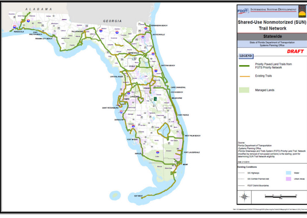
Since BikeWalkLee's inception in 2009, it has been a strong supporter of the vision of a connected and integrated statewide trail system throughout Florida.  [BWL 2016 Letter ] While a statewide trail map was developed in 1998, the initiative gained momentum beginning in 2014 when the State Legislature provided annual funding ($25 M/year) for the SUN Trail program that uses the Florida Greenways and Trails Plan and maps to prioritize funding for the system.  This Plan and maps (last updated in 2015) will guide implementation of the connected statewide trail system from 2018 through 2022.  Since 2015, the Lee MPO has proposed several new segments for the trail, which need to be incorporated into the updated maps.

We are concerned that the revised statewide trail maps contained in the draft FGTS update have deleted the Seminole Gulf Railroad right of way corridor between Bonita Springs and Estero that has been on the FGTS map since the beginning
as the primary spine for the Southwest Coast Connector (aka Gulf Coast Trail) in Lee County,.  It is critical that this trail be added back as a Priority trail before the update is finalized.  Why is this important? Because being a "Priority Trail" gives you priority for SUN Trail funds.  Bonita and Estero officials have been working jointly over the past 8 months to move this "rails-to-trails" project forward, with strong support from their communities. 


Please submit comments in support of this project as requested in the Lee MPO's email request (see below), or attend next week's public workshop in North Port (9/14) to express your support in person.  Thank you! 
 
Introduction (by Office of Greenways and Trails)

"The Florida Greenways and Trails Plan establishes the vision for implementing a connected statewide system of greenways and trails for recreation, conservation, alternative transportation, healthy lifestyles, a vibrant economy, and a high quality of life. The Office of Greenways and Trails (OGT) is updating the FGTS 5-Year Plan and holding 14 public open houses throughout the state. "


Lee MPO Email 9/5/17:
URGENT: Please Submit Comments to Office of Greenways and Trails to Restore the Seminole Gulf Alignment to the Priority Trails Map


The Florida Department of Environmental Protection has released its Final Draft Priority Trails Map for the Southern Region that includes Lee County, and it is disappointing to see that they have removed the Seminole Gulf Railroad (SGLR) alignment from the Draft 2018-2022 Update of the Priority Trails Map. This is inconsistent with the Lee MPO Board resolution that was adopted back in February 17, 2017 which urged the Florida Greenways and Trails Council to (1) add the proposed Coastal Loop to the Priority Trails Map while (2) maintaining the SGLR Right of Way as the primary spine for the Southwest Coast Connector (aka Gulf Coast Trail) in Lee County, and thereby continuing to maintain that alignment in the Priority Trails Map. That resolution was transmitted to the FDEP Office of Greenways and Trails (OGT) staff on the same day it was adopted by the Lee MPO. 

Staff had subsequent discussions with OGT staff where we had consistently and repeatedly urged OGT staff to recommend that the SGLR alignment be maintained while adding the Coastal Loop in the Draft Priority Trails Map Update. They had said that the OGT Council would not approve loops in urban areas, yet OGT staff went and added a proposed loop trail requested in Sarasota Manatee County in the draft Priority Trails Map for Council consideration, but denied our request. The Sarasota loop trail can be found in the West Central Florida Region Map.

A Joint Resolution was adopted by the Central Florida MPO Alliance and the TBARTA MPO Chairs Coordinating Committee in June 16, 2017, that had endorsed the Lee and other MPOs proposed changes to alignments in their respective counties to the South West Coast Connector (aka Gulf Coast Trail).

Please fill the attached comment sheet [Comment Form]:
asking OGT Council and staff to restore the SGLR ROW alignment in the Southern Region Draft Priority Trail Map. Make sure that you ALSO write in the comment sheet expressing your thanks and support to OGT staff for adding the Coastal Loop and the SR 78/80 Corridor in Lee County to the Draft Priority Trails Map. 

 In addition to Samantha Browne, please cc OGT Council Chair Brian Smith at smithozona@gmail.com . We would like you to send your comments as soon as possible, and if possible attend one of the public open houses either in Sebring or North Port for input on the draft priority map for the Southern Region to express your concerns in person. The open houses in Sebring and North Port are as follows:

9/6/17 UPDATE: SEPT. WORKSHOPS POSTPONED DUE TO HURRICANE IRMA
"The Public Workshops scheduled for September (see below) will be rescheduled for a later date due to the potential of Hurricane Irma impacting the state.  This will allow individuals to focus on preparing their communities and families for the storm.  The Office of Greenways and Trails will send out more information once new dates have been confirmed."

Thursday, September 14 – North Port
Morgan Family Community Center, Meeting Room A/B
6207 West Price Boulevard, North Port, FL 34291
4:00-7:00 ET


Monday, September 11 - Sebring
Bert J. Harris, Jr. Agricultural Center, Conference Room #2
4509 George Boulevard, Sebring, FL 33875

4:00-7:00 ET


Related BikeWalkLee Blog Posts:


October 12, 2016: Cape Receives $1.8 Million SUN Trail Grant to Design Multi-Use Trail in North Cape

March 9, 2016: Moser Column: Cross-country bicycling network offers local benefits

March 7,2016: BikeWalkLee supports Southwest Coastal Regional Trail


Report by Darla Letourneau

Wednesday, April 27, 2016

Cape Coral Police Department's Bicycle Safety Videos

Kudos to the CCPD for their focus on bicycle safety and all their efforts to educate the public, including these excellent new bicycle safety videos.

At the April 26th Lee MPO Bicycle Pedestrian Coordinating Committee (BPCC) meeting, Sargent John Kulko with CCPD made an informative presentation about the bicycle and pedestrian education and enforcement efforts underway in the Cape, with the goal of enhancing the safety of the community. 

 Thanks to assistance from an FDOT grant they have conducted 216 hours of enforcement, using a balanced approach (drivers, cyclists, and pedestrians).  They have placed particular emphasis on educating children, including education and enforcement of the requirement for kids under 16 to wear helmets.  They have also conducted bike safety rodeos and a summer bike safety camp for Oasis Middle School students.  They also have a bike patrol unit, which in addition to its regular duties, has been providing route security, safety and awareness for the monthly Cape Coral SWFL Critical Mass rides.
CCPD's Bike Safety Summer Camp

Sgt. Kulko also showed three excellent  PSA videos produced by the CCPD to educate the public about bicycling safety.  There is one 4 minute video about sharing the road and the rules of the road for both cyclists and drivers; then from that video, two shorter clips have been made into 30 second PSAs.  It's great to see the introduction and closing in each video by  a CCPD Captain, including this closing message on the full length video:
"Be aware, be considerate,  be safe, show respect.  When you share the road everyone gets there safely."

Be sure to watch the videos and share with your organizations and networks.

Full (4 minute) Share the Road/Rules of the Road PSA


The Cape's plan is to put these PSA spots on "electronic message boards" in key public locations, businesses, restaurants, bike shops, Chambers of Commerce, etc., just as the Sanibel Bicycle Club has done with their safety video and their safety PSA slides on "message boards".  It's great to see a successful approach in one Lee County community being adapted and implemented in other communities.
So, be inspired and be the next community to take these ideas and examples and adapt them for use in your community.

Thanks to the Cape Coral team!

Report by Darla Letourneau

Monday, March 7, 2016

BikeWalkLee supports Southwest Coastal Regional Trail

Vision of Florida interconnected trail system
It's exciting to see the vision of a Florida statewide system of interconnected trails beginning to take shape.  The first section of this network is well underway--the 275 mile Coast-to-Coast Trail from St. Petersburg to Cape Canaveral National Seashore.

For the past two years, Lee and Collier County MPOs developed and approved the route for our section of the Southwest Coastal Regional Trail, which is now vying with many other potential trail segments to be the next priority regional trail segment (after the Coast to Coast Connector) to move forward.  In 2015, the Florida legislation created a new program called SUNTrails (Shared-Use Nonmotorized (SUN) Trail Network, to be managed by FDOT with an annual funding level of $25 million.

Lee Co. segment of SW Coastal Regional Trail
A broad alliance comprised of the Tampa Bay Area Regional Transportation Authority (TBARTA) and the nine MPOs in Southwest Florida are working together to push for the Southwest Coastal Regional Trail as the next trail segment to be chosen by the Florida Greenways and Trails Council.  If selected it would begin to receive funding from FDOT's SUNTrails program.   The Southwest Coastal Regional Trail is part of the "shortlist" of 7 trails selected for further evaluation.  The Council will soon pick it's top recommended trail and submit it to FDOT for selection.  We have our collective fingers crossed. A special thanks to Ron Gogoi of the Lee MPO staff for his special efforts on this initiative.

This is a long term project that many of us will never see completed in our lifetime but it will be wonderful for our grandchildren.  In the near future the Coast-to-Coast Trail will be completed and it will show everyone the incredible economic, mobility, and quality of life potential of a interconnected trail system.  I for one can't wait!!

Below is the letter of support that BikeWalkLee submitted, along with a link to the region-wide alliance letter of support.

Report by Darla Letourneau 
                                                                                                                                           BikeWalkLee's Letter of Support for Southwest Coastal Regional Trail
February 22, 2016

Dear Mr. Chiaramonte,

BikeWalkLee is an award-winning volunteer community coalition with 70 supporter organizations raising public awareness and advocating for complete streets in Lee County.  Since our inception in 2009, we have been strong supporters of the vision of a connected and integrated statewide trail system throughout Florida. 
               
We were an early supporter of the River of Grass Greenway, which both Lee and Collier MPO Boards have made a funding priority over the past 5 years.  We also urged our Lee Legislative Delegation to support the 275 mile Coast-to-Coast Trail from St. Petersburg to Cape Canaveral National Seashore.  Our annual letter to the Lee Legislative Delegation for the past four years has made bike tourism and the statewide network of bike/ped paths, now called SunTrail, one of our top priorities. 

In the Fall of 2014, the Florida Greenways and Trails Foundation CEO, Dale Allen, made a well-received presentation to a joint Lee/Collier MPO Board meeting about the vision of a statewide trail system. This vision energized the MPO staff and advocates in both counties to form a joint working group in early 2015 that developed the best route for a regional trail in Southwest Florida, called the Southwest Coast Connector (N2N).  In early 2016 the Lee MPO submitted grant applications for SunTrail funds to undertake two projects on the Southwest Coast Connector--the Kismet Parkway shared use path in Cape Coral, which would be part of the Charlotte Lee Hendry Trail; and funds for the PD and E study for the last segment of the popular John Yarborough Linear Park Trail in Fort Myers.  Other segments of the trail going through Lee County are either planned, programmed, or existing.

We see bike tourism as a winning economic development strategy for Florida.  This lucrative niche market is especially attractive for international travelers and a younger demographic.  With Florida's temperate winters and flat terrain, the potential for destination bike tourism has an enormous potential for high returns on our investment in Florida. 
Lee County's current Tour de Parks route

The $10 million federal TIGER grant awarded in 2013 to the Lee MPO for its Complete Streets Initiative Project will be completed  by the end of 2016, setting the stage for enhanced economic benefits from bike tourism, which would be greatly enhanced by a trail system that linked Lee County to Collier County to the South and all the way to Tampa to the North. 
 
TIGER Complete Streets Initiative
Bike tourism is already gaining traction in Lee County with the recent completion of Cape Coral's 90-mile bicycle routes system.  By the end of this year, there were be 14.3 miles of additional shared use paths as result of the TIGER grant, increasing the current connected shared use path system in the area (Lee County's Tour de Parks Loop) to a total of almost 50 miles.  In addition, last year FDOT programmed funds to conduct a PD and E study for a shared use path that will connect the Cape Coral system to Pine Island, which already has a shared use path the length of the island on Stringfellow Rd.  This new 2.3 mile connection will connect the 90 mile system in Cape Coral to the 5.6 mile path on Pine Island, creating almost 98 miles of a connected path system.

Cape Coral's 90 Mile Bicycle Route

Commitment to improving our bike/ped facilities network and the safety of its users is a high priority by both the elected bodies and communities  in Lee County, as evidenced by our growing number of communities designated as Bicycle Friendly Communities (BFC)--in 2014 Sanibel was elevated to Silver status, and in 2015 Cape Coral was designated as a Bronze BFC.  In the larger SWFL, there are two other BFC's--Punta Gorda, joined by Naples in 2015.  SWFL has worked hard over the past seven years to develop comprehensive bike/ped programs, including expanding and improving the bike/ped network.   SWFL is ready to take on the next big challenge-- the Southwest Coast Connector Trail.

In summary, BikeWalkLee strongly supports the Southwest Coast Connector, and urges the Florida Greenways and Trails Council to select our region as the next portion of the statewide system to work on.   We look forward to working with all the governmental and advocate partners in this regional initiative.

Darla Letourneau
On behalf of the Steering Committee
BikeWalkLee

Related Links:
Regional letter by TBARTA and MPO alliance

Lee County portion of SW Connector Trail

FDOT PowerPoint on SUNTrail 

Wednesday, February 10, 2016

Moser Column: Wayfinding is a vital component of our bike/pedestrian network

Dan's column reminds us of why wayfinding (signs and maps) is important to a successful bike/ped network, helpful to new residents and visitors, and a basic requirement for becoming a bicycle-friendly community (BFC).  Cape Coral and Sanibel (our two BFCs) are leading the way...now we need the other communities in Lee County to step up to the plate, esp. given the federal TIGER grant that was based on connecting our existing loops.

Florida Weekly, Outdoors Section, 2/10/16 

Cape Coral is sometimes known as a “can’t get there from here” place for many, including bicyclists, runners and walkers who are unfamiliar with the city’s extensive canal network. Even though there exists quite an extensive array of pathways, bike lanes and lightly trafficked neighborhood roads that allow cyclists and pedestrians safe passage around much of the city, until recently getting from here to there was often frustrating because of dead-ends created by canals that also serve as effective barriers by default. But thanks to ambitious community volunteers, cooperative city staff and elected officials, and astute business people who seized an opportunity, more than 90 miles of non-motorized routes were signed and marked to make it possible to know where one was and where one was heading.
As motorists we expect — and almost always get — adequate informational and directional markings and signage. In fact, it’s one of the basics of transportation planning and traffic management. So why is that generally not the case for us when we’re non-motorists, at least here in Southwest Florida? Cape Coral and Sanibel are proud exceptions to this problem. Why is it that when we’re on bike and foot we’re expected to speculate on our whereabouts and how to get where we’re going, having to use signs meant for motorists — which frequently don’t provide enough useful/visible information — to find our way? From my perspective, the answer is clearly a matter of priorities among transportation decision makers who are either unconcerned with anything except moving cars or are ignorant of the need. In this day and age it’s hard to believe anyone who’s in such a position could be ignorant of the need.

Signs like this are very helpful, especially for visitors and new residents.
At any time the powers-that-be can put forth the resources to do what Cape Coral, Sanibel and many other communities throughout Florida and the U.S. have done by finally adding wayfinding — easy-to-read signs — to our growing bike/ped network. For one thing, it’s a basic requirement for becoming a bike-friendly community, if that even matters to those who can make a difference. 
Wayfinding is also critical for visitors and new or part-time residents, so it makes sense from a tourism and economic development perspective to help folks get to their destinations. And having the confidence to make a trip by bike or foot safely and efficiently will get cars off the road, which equates to reducing the need to continually spend a staggering amount of tax dollars on road capacity projects, something we continue to do in our unattainable attempt to build our way out of congestion.
A partial wayfinding attempt was made a few years ago when two popular bike routes were designated as such and then heavily promoted. Signs were placed on the 20-plus-miles mile Tour de Park route and less extensive University Loop. Unfortunately the work was left incomplete and didn’t include any other part of our network. But because of requirements written into the significant TIGER grant we were recently awarded, that job could and should be completed and eventually expanded to include our entire network. Of course, getting it done is predicated upon cooperation from each of the various jurisdictions, from Lee County to FDOT to our municipalities. 
At least one is questioning the value of providing this very basic and necessary service for its many residents and visitors, even though the cost of doing so would be a drop in the bucket when compared to what is routinely spent on other transportation projects. Ask your elected representatives and transportation officials what their positions are on this matter — you may be surprised about what you learn. In the meantime, efforts to make this happen will continue in the hope that those objecting will see the light or can be worked around. To learn more and stay abreast of progress and continued resistance, visit BikeWalkLee’s blog at bikewalklee.blogspot.com.
Until next time, I’ll look for you on the roads and pathways.
Upcoming events
Running/walking:
>> Rotary’s Run for the Rose Garden 5K, Saturday, Feb. 13, Rotary Park, Cape Coral, 3dracinginc.com
>> Edsion Fest 5K, Saturday, Feb. 20, downtown Fort Myers, ftmyerstrackclub.com
>> Hooters Half-Marathon, Sunday, March 6, Fort Myers, hootershalfmarathon.com
Cycling and other events:
>> SWFL Critical Mass, Friday, March 4, downtown Fort Myers, meetup.com/Biking-SWFL
>> Ride for Fallen Heroes, Sunday, March 6, Estero Trek, brotherhoodride.com
>> 18th annual Royal Palm Classic, Sunday, March 13, Fort Myers Brewery, Gateway, caloosariders.org
Dan Moser is a long- time bicycle/ pedestrian advocate and safety professional who cycles, runs and walks regularly for transportation, recreation and fitness. Contact him at bikepedmoser@gmail.com or 334- 6417.